SOUTH ATLANTIC DIVISION (SAD) REGIONAL SEDIMENT MANAGEMENT CENTER OF EXPERTISE

ESTABLISHED IN 2015

The Center was established to support division-wide RSM implementation:

  • Serves as a resource to pool and leverage talent from across SAD to solve challenging problems and implement solutions
  • Helps to define the vision for the long-term economic and environmental sustainability of the coastal Navigation (NAV)and Flood Risk Management (FRM) missions


FOCUS AREAS AND IMPLEMENTATION

  • RSM Project Implementation
  • Planning and Policy Support
  • Engineering and Design
  • Contracting and Cost Estimating
  • Directed Studies
  • Pilot Projects
  • Outreach and Education


RSM VALUE IN SAD

  • Implementation of RSM principles provides a total annual value of $104 M in SAD
  • Supports:
  • Actionable RSM strategy to most efficiently execute the coastal NAV and FRM program budgets
  • Innovation
  • Maximining the value of dredging events by integrating RSM opportunities
  • Long-term coastal resilience

BENEFICIAL USE OF DREDGED MATERIALS FOR COASTAL HABITAT RESILIENCE

Map of the eastern U.S. highlighting the coastal area from North Carolina to Georgia.

USACE dredges over 39 million cubic yards of sediment from federal navigation channels in North Carolina, South Carolina, and Georgia, with approximately 31% being used beneficially. This project is a collaborative, data-driven approach to identify and prioritize beneficial use dredge material (BUDM) opportunities for coastal habitat resilience throughout Georgia, South Carolina, and North Carolina. The project utilizes existing data and tools from many different resources, and applies a methodical approach for BUDM site identification and metrics for scoring to prioritize opportunities on a regional scale. This project is funded by the U.S. Army Corps of Engineers (USACE), South Atlantic Division, and a National Fish and Wildlife Foundation (NFWF) grant provided to project partners’ Manomet and The Coastal States Organization (CSO).

The main project goals are to: identify areas of concern and regional-priorities to improve coastal ecosystem health and long-term resilience, increase BUDM opportunities, and develop state partner teams to advance BUDM implementation in the near-term. The project began in July 2023, and will conclude September 2024, with the identification of 4-6 new BUDM sites in each state, a public-facing webapp tool for communicating Five Year regional Dredge Material Management Plans, and state partner teams to continue advancing and implementing BUDM projects for coastal habitat resilience. 

Link to Project Overview 

Link to Manomet Full Proposal


Recent Work

The U.S. Army Corps of Engineers (USACE) Southeast Florida Sediment Morphodynamics (SEFMOD) study began in 2019 as the first multi-project scale field measurement and modeling study in Southeast Florida. The study took a Regional Sediment Management (RSM) approach with more detailed studies at Lake Worth Inlet (Palm Beach Harbor), Port Everglades Harbor, and Miami-Dade County (MDC) to include Baker’s Haulover Inlet (BHI). The main goals were to identify more sustainable solutions to improve sediment management for the region and to identify strategies that would decrease management costs at project specific sites.

The study acquired data across the region to establish an understanding of the natural system and the metoceMap of Lake Worth Inlet, Port Everglads and Miami Dadean processes that  drive sediment transport so conceptual and numerical models could be used to forecast sediment transport pathways leading to improved sediment management decisions.

Project Specific Summaries;


Miami-Dade County

Port Everglades

Palm Beach Harbor (Lake Worth Inlet)


If you have specific data or model requests related to the study, please email laurel.p.reichold@usace.army.mil


Kings Bay Naval Submarine Base Beneficial Use of Dredge Material Study

Command Navy Region Southeast, Naval Submarine Base (NSB), Kings Bay, GA, and the U.S. Army Corps of Engineers has partnered with local stakeholders to discuss Beneficial Use of Dredged Material (BUDM) and explore implementation opportunities. Approximately 1 million cubic yards (MCY) of sediment must be dredged out of the subbase channel every year to maintain safe navigation and is estimated to double by 2050 due to sea level rise. The surrounding marsh habitat has already lost approximately 770 acres since 1932 and is predicted to lose another 500 acres by 2050. The stakeholder group reviewed engineering and scientific analyses of historic, current, and future conditions to discuss possible solutions for the NSB Kings Bay region. The dredging mission at NSB Kings Bay is essential to supporting the Navy’s nuclear deterrence mission. Currently, dredged sediments are placed into upland confined disposal sites known as Dredge Material Management Areas (DMMAs). With an estimated 11 MCY of capacity remaining, beneficial use of the dredged material can provide multiple benefits when compared to taking the material to offshore disposal sites once the DMMA sites are at capacity.

The recently conducted work, on behalf of the Navy and managed by the U.S. Army Corps of Engineers South Atlantic Division’s Regional Sediment Management Center of Expertise, was performed by contracted partners Taylor Engineering, Marstel-Day, LLC, and EA Engineering, Science, and Technology, Inc. The analyses included hydrodynamic and sediment transport modeling of shoaling reduction alternatives, as well as historic, current, and future marsh assessments of the surrounding region. Initial study results of utilizing dredged material to beneficially restore marsh and reinstate historic hydrologic conditions demonstrated a potential shoaling reduction of up to 75%. Additional stakeholder engagements are planned to inform the Navy’s Beneficial Use of Dredged Material Strategic Implementation Plan, scheduled for completion at the end of 2025. For more information, please contact Laurel.p.reichold@usace.army.mil


LINKS: Kings Bay Historical Marsh Analysis Report

LINKS: Kings Bay Field Sampling Plan

LINKS: BU Site Scoping Charette Presentation Nov 14, 2024

LINKS: Evaluation of the Current Marsh Habitat at Naval Submarine Base Kings Bay

JEKYLL CREEK BENEFICIAL USE PILOT PROJECT

The Jekyll Creek team was recently awarded the FY20 USACE Sustainability Green Dream Team Award and will be featured in the upcoming “Engineering With Nature: An Atlas Vol. 2” available on 7 April 2021 at: https://ewn.el.erdc.dren.mil/.

The Jekyll Creek Beneficial Use Pilot Project is a collaboration between USACE (RSM Center, Savannah District, Jacksonville District), state and federal agencies, stakeholders, academia, and industry to develop both environmentally and economically sustainable beneficial use of dredged material solutions for maintaining Navigation projects in the State of Georgia and to support coastal resilience throughout SAD.

Through collaboration and the shared vision of the team, USACE and our partners developed and successfully executed two innovative beneficial use placement strategies consistent with RSM principles which are Open Water Dispersal and Thin Layer Placement (TLP).

The strategies were the first to be executed by USACE in SAD and a first for the State of Georgia. These environmentally acceptable and economically efficient strategies provide opportunities for future RSM applications in Georgia and throughout the southeast with potential applications across USACE divisions. Incorporation of these two placement strategies could help the USACE Navigation program take a big step towards the goal 100% beneficial use of dredged material.

SOUTH ATLANTIC COASTAL STUDY (SACS)

SOUTH ATLANTIC COASTAL STUDY (SACS)


The SACS was initiated in 2018 and will identify risks and vulnerabilities to increased hurricane and storm damage as a result of sea level rise, emphasize Regional Sediment Management practices to sustain/enhance current coastal storm risk management measures, recommend measures to address coastal vulnerability of areas affected by SLR, and develop a long-term strategy to address increased hurricane/storm damages resulting from SLR, enhance resiliency, and lower risks. The study will be completed in August 2022 and information about the study and associated products and data is available at: https://www.sad.usace.army.mil/SACS/ and https://data-sacs.opendata.arcgis.com/.

SACS includes 12 study products and completed products include the Tier 1 Risk Assessment, 2020 RSM Optimization Update, and Sand Availability and Need Determination (SAND) study. The 2020 RSM Optimization Update and SAND study were RSM-focused products and are highlighted below.

SAND AVAILABILITY AND NEED DETERMINATION (SAND) STUDY

The SAND study quantifies sand needs and available sand resources for all current beach nourishment projects, both federal and non-federal, in SAD for the next 50 years. SACS utilized a stakeholder and consensus building approach to achieve Congressional requirements for SACS. The SAND study exemplifies this collaborative approach by executing the project with 12 federal and state agencies led by technical experts from all five SAD districts and a contracted coastal engineering firm.


Sand needs for all beach nourishment projects and available sand resources (e.g. offshore, RSM, and/or upland sources) were quantified by county. Regionally, a total of 1.3 billion CY of sand are needed to support the 50-year sand needs and 1.5 billion CY of sand resources were identified. While regional sand resources are greater than documented sand needs as of today, economically viable long-term sources are limited in many areas across the region. Sand shortages are documented in numerous counties of every state in SAD and municipalities in Puerto Rico. Further, critical sand shortages were identified across regions of North Carolina, South Carolina, Florida, Alabama, and Mississippi. Considering the SAND study only accounted for permitted or near-permitted projects across SAD, it’s likely that additional projects will be permitted in the coming years, increasing the demand for beach quality sand.

The SAND report, web apps, data downloads including the SAND Dredged Material Management Areas Offloading Study are available at: https://data-sacs.opendata.arcgis.com/pages/sand.

2020 RSM OPTIMIZATION UPDATE

2020 RSM OPTIMIZATION UPDATE

The 2020 RSM Optimization Update builds on the efforts of the 2016 SAD RSM Optimization Pilot which was developed to help identify additional means to streamline existing processes and ensure solutions are increasingly economical and environmentally sustainable across USACE authorities and missions. The 2020 RSM Optimization Update was initiated through SACS to support the identification and continued implementation of sustainable solutions under current authorities.

The Update analyzed over 70 USACE Navigation and Coastal Storm Risk Management projects in SAD and includes fact sheets for each project that include placement strategies, volumes, frequencies, cost, and future opportunities. The report highlights beneficial use strategies implemented across SAD including beach placement, nearshore placement, thin layer placement (TLP), open water dispersal, and habitat creation. To learn more about RSM strategies across SAD, download the report at: https://www.sad.usace.army.mil/SACS/.

RSM IN SOUTH CAROLINA

The Charleston District has numerous active RSM initiatives in progress and on the horizon at Charleston Harbor, Folly River, and Folly Beach. Offshore artificial reefs (see imagery below), berms around the Ocean Dredged Material Disposal Site (ODMDS) to support fish habitat and sediment containment, restoration of Crab Bank, and beach placement of sand at Morris Island to support the south jetty terminus are all in the works at Charleston Harbor.


The Folly River Entrance Channel is scheduled to be dredged in spring/summer of 2021 and approximately 60,000 cubic yards of sand will be placed in the nearshore at Folly Beach. To evaluate the effectiveness of the placement strategy, the district is supporting a 2-year sediment tracer study and Argus camera system deployment. Nearshore placement is a RSM strategy to reduce storm damage impacts and increase coastal resilience. 

MANATEE HARBOR BENEFICIAL USE OFFLOADING

The Jacksonville District is in the process of offloading approximately 140,000 cubic yards from the Manatee Harbor Dredge Material Management Area (DMMA) to Washington Park (see image to left), owned by Manatee County (FL).  Dredged material capacity at Manatee Harbor was nearly exhausted and the project provides capacity for future dredging events to support for future maintenance dredging. 


Using the offloaded dredged material as fill, the County has a master plan to convert the Washington Park borrow pit into an environmental preserve aiming to mimic the historical ratio of wetland and upland habitats. The beneficial use offloading strategy supports long-term maintenance of the Manatee Harbor Channel and provides social and environmental benefits for Manatee County. For additional information about how the project is fits into Manatee County’s plan for Washington Park, visit www.mymanatee.org/washingtonpark.

MISSISSIPPI COASTAL IMPROVEMENTS PROGRAM (MSCIP)

The Mobile District recently completed the construction of the Mississippi Coastal Improvements Comprehensive Barrier Island Restoration project with the placement of over 22 million cubic yards of sediment to restore the system.  The project was recently highlighted in a podcast “Engineering with Nature”, exploring how infrastructure will play a role in worldwide recovery as they highlight success in coastal collaboration and will also be featured in the upcoming “Engineering With Nature: An Atlas Vol. 2” available on 7 April 2021 at: https://ewn.el.erdc.dren.mil/.

The Mississippi Coastal Improvements Comprehensive Barrier Island Restoration project is a testiment to the collaboration between USACE,  state and federal agencies, stakeholders, academia, and industry to develop a triple win that provides environmental, economic and social benefits; integrating in regional sediment management practices and engineering with nature techniques. 
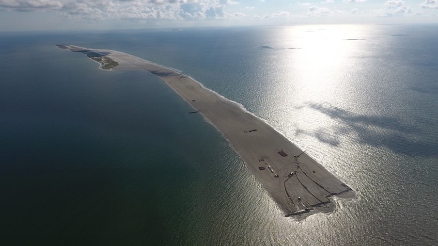


Ship Island (During-construction photo of the closure of the breach, looking east)
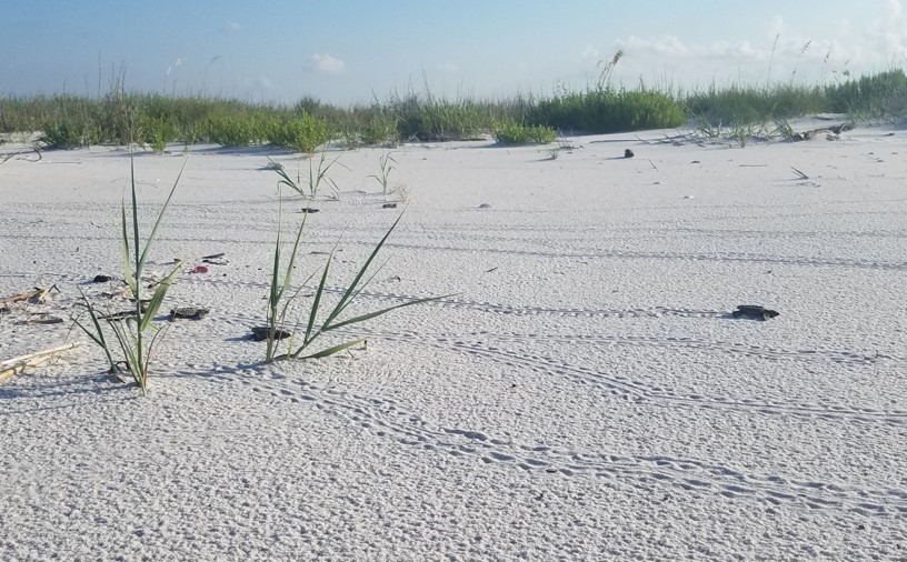
Ship Island Turtle Hatching


FY21 NATIONAL RSM PROGRAM FUNDED PROJECTS

The National RSM Program supports initiatives that develop and demonstrate sustainable practices that systematically increase benefits and reduce lifecycle costs for the Corps Navigation, Flood Risk Management, and Environmental missions through an annual Request for Proposals (RFP) process. Four SAD proposals were funded for FY21.


Jacksonville District: Northeast Florida RSM – A Guide to Using Dredged Material for Estuarine Restoration

Mobile District: Field Implementation of Belowground Biomass for Increased Dune Stability and Resiliency

Mobile District: Synthesis of Sediment Budget Assessments along the Northern Gulf of Mexico from the Pearl River to Apalachicola Bay

Savannah District: Identification of Dredged Material Beneficial Uses from Geophysical Analysis of Sediment Borings


OTHER LINKS OF INTEREST

Hydrographic surveys

https://navigation.usace.army.mil/survey/hydro


Optimization Tool

http://sajgeo.saj.usace.army.mil/rsm-dash


Contact Information

Director

904-232-1458


RSM.Center@usace.army.mil