Wilmington District Regulatory Division
North Carolina
Regulatory Announcements
General regulatory announcements, news, events, and public meetings.
https://rrs.usace.army.mil/rrs/public-notices is the primary location for all Regulatory Public Notices issued across USACE.
USACE seeks public comments on potential future changes to the nationwide permits to increase permitting efficiency
USACE announced it is seeking input from all interested parties on ways to increase the efficiency of the nationwide permit program. A public notice soliciting input on potential future changes to the nationwide permits was published in the March 16, 2026, Federal Register at https://www.federalregister.gov/d/2026-05051. USACE will accept written comments through May 15, 2026. Comments should be submitted through the Federal eRulemaking portal at www.regulations.gov at docket number COE-2026-0001, or by mail to U.S. Army Corps of Engineers, Attn: CECW-CO-R, 441 G Street NW, Washington, DC 20314-1000.
U.S. Army Corps of Engineers announces publication of 2026 nationwide permits
2026 Nationwide Permits and Wilmington District Regional Conditions
On January 8, 2026, the U.S. Army Corps of Engineers (USACE) published a final action in the Federal Register (91 FR 768) announcing the reissuance of 56 existing nationwide permits (NWPs) and one new NWP, as well as the reissuance of NWP general conditions and definitions with some modifications. One NWP was not reissued. These 57 NWPs will go into effect on March 15, 2026, and will expire on March 15, 2031.
Wilmington District Public Notice and 2026 Regional Conditions
Permitting
Wilmington District Regional General Permits
The Wilmington District maintains 16 Regional General Permits for activities occurring in waters of the United States in North Carolina.
2026 Wilmington District Nationwide Permits and Regional Conditions
2026 Nationwide Permits with SAW Regional Conditions
2021 Wilmington District Nationwide Permits with Regional Conditions
The Wilmington District has issues regional conditions that apply to activities authorized by Nationwide Permits (NWP) in North Carolina.
North Carolina Department of Transportation (NCDOT) Funding Agreement
The U.S. Army Corps of Engineers, Wilmington District currently accepts and expends North Carolina Department of Transportation (NCDOT) funds for expediting Department of the Army (DA) permit review on transportation projects. This is done in accordance with Section 214 of the Water Resources Development Act of 2000, as amended by the Federal Water Resources Reform and Development Act of 2014. The formal agreement between the Wilmington District and NCDOT can be viewed at the following link: (select North Carolina under the state pick list on the Active Agreements list on the page.)
http://www.usace.army.mil/Missions/Civil-Works/Regulatory-Program-and-Permits/Section-214/
The latest agreement (Supplement #2) can be viewed here.
In addition, you may view all DA permit decisions completed since the implementation of this agreement at the following link:
https://permits.ops.usace.army.mil/orm-public#
Western North Carolina Trout Watersheds
Several watersheds in Western North Carolina are subject to special conditions due to the presence of waters that contain trout habitat.
For Regional General Permits (RGPs) and Nationwide Permits (NWPs), permittees must:
- Submit a Pre-construction Notification (PCN) prior to commencing any activity involving a discharge of dredge or fill material into streams, waterbodies or wetlands within the currently designated trout watersheds of North Carolina; and
- Provide a copy of the PCN to the appropriate North Carolina Wildlife Resource Commission (NCWRC) office, or the Eastern Band of Cherokee Indians (EBCI) to facilitate the determination of any potential impacts to designated Trout Waters.
Counties containing trout watersheds: (see watershed maps):
You can also determine if your project is located within a Trout Watershed by checking the NC DEQ Find Your HUC in North Carolina web mapping application. Instructions for using the mapper application.
The Feature Layer can also be downloaded here: Trout Watershed Feature Layer
Endangered Species and Critical Habitat
The Endangered Species Act (ESA) protects federally listed species and their critical habitats, and the U.S. Army Corps of Engineers (USACE) plays a key role in ensuring compliance through its permit programs. Section 7 of the Endangered Species Act directs all federal agencies to use their existing authorities to conserve threatened and endangered species and, in consultation with the Service, to ensure that their actions do not jeopardize listed species or destroy or adversely modify critical habitat.
In partnership with the U.S. Fish and Wildlife Service (FWS) and the National Marine Fisheries Service (NMFS), USACE reviews applications using the best available data to assess potential impacts on endangered species and designated habitats, while also relying on applicants to self-report possible effects.
Programmatic Biological Opinions (PBOs)
A Programmatic Biological Opinion (PBO) is a document issued under the Endangered Species Act that evaluates the potential effects of a broad or recurring federal action such as a long-term plan or a group of similar projects on federally listed species and their critical habitats. For the U.S. Army Corps of Engineers (USACE), PBOs provide a streamlined approach to environmental compliance by covering multiple future actions under one biological opinion. This allows the USACE to implement routine activities, like maintenance or permitting, more efficiently while still ensuring protection of threatened and endangered species. Below are the Programmatic Biological Opinions currently available for use in North Carolina.
Standard Local Operating Procedures for Endangered Species (SLOPES)
Standard Local Operating Procedures for Endangered Species (SLOPES) are agreements developed between the U.S. Army Corps of Engineers (USACE) and the U.S. Fish and Wildlife Service (USFWS) to streamline the Endangered Species Act Section 7 consultation process for certain types of activities that are not likely to adversely affect listed species or their habitats. SLOPES outline standardized procedures and criteria for evaluating permit applications, enabling USACE to quickly determine whether an activity qualifies for expedited review without requiring separate consultation for each individual project. This improves efficiency while maintaining compliance with the ESA. Below are the approved SLOPES currently available for use in North Carolina.
Online Resources
U.S. Fish and Wildlife Service, Interactive Planning Tool, the Information, Planning, and Consultation System (IPaC): An interactive project planning tool that helps provide a quick site proximity screening to assist before you have designed your project.
Geospatial (GIS) Data
(shapefile format in zip archive, data courtesy US FWS)
Use system downloader or right click and "save target as" and save archive to saved destination.
Essential Fish Habitat (EFH)
The district consults with NOAA Fisheries, as authorized by the Magnuson Stevens Act, to protect the nation's fisheries. NOAA Fisheries, also known as the National Marine Fisheries Service (NMFS) designates areas that are essential to the sustainability of the fishery resource. The designation and protection of those areas important to the survival of the fisheries are known as Essential Fish Habitat (EFH). All federal agencies whose work may affect fish habitats must consult with NOAA Fisheries. EFH is described for federally managed species, some of which have habitats in state waters.
EFH Explained
Essential Fish Habitat (EFH), are defined as those waters and substrate necessary to fish for spawning, breeding, feeding, or growth to maturity. Section 303(a)(7) of the Magnuson-Stevens Act, 16 U.S.C. 1801 et seq., as amended by the Sustainable Fisheries Act in 1996, requires that Fishery Management Plans (FMPs) describe and identify essential fish habitat (EFH) within the U.S. Exclusive Economic Zone (EEZ) for all life stages of each species in a fishery management unit. Available information should be interpreted with a risk-averse approach to ensure that adequate areas are protected as EFH for the managed species. In North Carolina, salt marshes, oyster reefs, and seagrass beds are designated EFH for red drum and penaeid shrimp, species managed cooperatively by state and federal authorities.
EFH Tools and Info
Maps for essential fish habitat (EFH), habitat areas of particular concern, and EFH areas protected from fishing. The online viewer shows species that spawn, grow, or live in a chosen location in map or report format.
Designated Waters
Maps of Designated Western NC Stream Corridors and Buffers By CountyThe Wilmington District Corps of Engineers works with other state and federal agencies to ensure protection of the water resources of North Carolina. To ensure consistency in the rules that protect water resources, the Corps may include additional, special permit conditions for waters that have state or federal protection designations.
Please review the required general and regional conditions and any applicable certifications or consistency requirements for the permit for which you are applying.
Waters Classified by North Carolina Division of Water Resources
With very few exceptions, all surface waters in North Carolina carry a classification. On this page (LINK), you can learn about the classification process, how classifications may affect you and look up the classification of a stream.
High Quality Waters (HQW)
Supplemental NC DWQ classification intended to protect waters with quality higher than state water quality standards. In general, there are two means by which a water body may be classified as HQW. They may be HQW by definition, or they may qualify for HQW by supplemental designation and then be classified as HQW through the rule-making process.
- The following are HQW by definition:
- (Water Supply) WS-I, WS-II,
- SA (shellfishing area),
- ORW (outstanding resource water),
- Waters designated as Primary Nursery Areas (PNA) or other functional nursery areas by the Marine Fisheries Commission, or
- Native and special native (wild) trout waters as designated by the Wildlife Resources Commission.
- The following waters can qualify for supplemental HQW designation:
- Waters for which DWQ has received a petition for reclassification to either WS-I or WS-II, or
- Waters rated as Excellent by DWQ.
Outstanding Resource Waters (ORW)
Supplemental NC DWQ classification intended to protect unique and special waters having excellent water quality and being of exceptional state or national ecological or recreational significance.
To qualify, waters must be rated Excellent by DWQ and have one of the following outstanding resource values:
- Outstanding fish habitat or fisheries,
- Unusually high level of water-based recreation,
- Some special designation such as NC or National Wild/Scenic/Natural/Recreational River, National Wildlife Refuge, etc.,
- Important component of state or national park or forest, or
- Special ecological or scientific significance (rare or endangered species habitat, research or educational areas).
No new discharges or expansions of existing discharges shall be permitted.
There are associated development controls enforced by DWQ. ORW areas are HQW by definition.
North Carolina Division of Coastal Management (DCM) Special Waters
Waters Classified by NC Division of Coastal Management
Coastal waters in North Carolina are managed by the NC Division of Coastal Management (DCM) under the authority of the Coastal Area Management Act (CAMA).
Areas of Environmental Concern (AEC)
The Division of Coastal Management is responsible for maintaining estuarine Areas of Environmental Concern (AECs) and establishing Specific Use Standards that specify the types of projects and construction methods that may be located/used in AECs. DCM manages construction activities through the issuance of CAMA development permits.
Western North Carolina Special Waters
Western NC Streams and Buffers
The Wilmington District has determined that projects in these areas require the applicant to submit a pre-construction notification (PCN) so the district can review projects for potential effects to historic sites. A PCN is required for activities located within 0.5 mile on either side of the listed waters, or within 0.75 mile of the Little Tennessee River, as measured from the top of the bank of the respective water (i.e., river, stream, or creek).
Listed Western NC Wates and Corridors by Stream Name
- Brasstown Creek
- Burningtown Creek
- Cane River
- Caney Fork
- Cartoogechaye Creek
- Chattooga River
- Cheoah River
- Cowee Creek
- Cullasaja River
- Deep Creek
- Ellijay Creek
- French Broad River
- Garden Creek
- Hiwassee River
- Hominy Creek
- Iotla Creek
- Little Tennessee River (within the river or within 0.75 mile on either side of this river)
- Nantahala River
- Nolichucky River
- North Fork French Broad River
- North Toe River
- Nottley River
- Oconaluftee River (portion not located on trust/EBCI land)
- Peachtree Creek
- Shooting Creek
- Snowbird Creek
- South Toe River
- Stecoah Creek
- Swannanoa River
- Sweetwater Creek
- Tuckasegee River (also spelled Tuckaseegee or Tuckaseigee)
- Valley River
- Watauga Creek
- Watauga River
- Wayah Creek
- West Fork French Broad River
Maps of Designated Western NC Stream Corridors and Buffers by County
Geospatial Data (KMZ files) of Western NC Stream Buffers
Western NC Waters with Reporting due to EBCI Cultural Heritage Protection Buffers:
Cultural Resources
Section 106 of the National Historic Preservation Act of 1966 (NHPA) provides that properties and districts listed in or eligible for listing in the National Register of Historic Places be considered in the planning of federal undertakings, which include activities permitted by the federal government. During the review of all Department of the Army (DA) permit applications, the U.S. Army Corps of Engineers must ensure the requirements set forth in the NHPA have been satisfied, including any required coordination with the State Historic Preservation Office.
The procedures the Corps must follow to ensure compliance with the NHPA are provided in federal regulations at 33 CFR 325, Appendix C and 36 CFR Part 800. In addition to the requirements of the NHPA, all historic properties are subject to consideration under the National Environmental Policy Act and the Corps' public interest review requirements contained in 33 CFR 320.4. Therefore, the potential effects to historic properties, which may include previously unidentified archaeological resources, are considered in the Corps' decision on every DA permit application.
More Information
Mitigation
Each year, property owners start construction and/or development projects that may affect the nation s aquatic resources, which includes rivers, streams, wetlands, lakes, sounds and waters in and offshore North Carolina. According to the Clean Water Act, all proposed activities and projects must make every effort to avoid or minimize impacts to these aquatic resources and prohibits the discharge of dredged or fill material into wetlands, streams, and other waters of the United States unless a permit is issued by the US Army of Engineers (USACE) or an approved State agency. The primary goal of the Clean Water Act (CWA) is to restore and maintain the chemical, physical, and biological integrity of the Nation s waters." Therefore, before beginning work that could impact the function and quality of these waters, a permit from the U.S. Army Corps of Engineers is often required.
In instances where impacts are unavoidable, USACE may require compensatory mitigation to offset losses of aquatic resources and mitigation requirements must be considered, as outlined in the Compensatory Mitigation for Losses of Aquatic Resources Final Rule (33 CFR Part 325 and 332; 40 CFR Part 230) in April 2008.
What is Mitigation?
Compensatory mitigation is the restoration, establishment, enhancement, or preservation of aquatic resources for the purpose of offsetting losses of aquatic resources resulting from activities authorized by USACE s permits.
Mitigation Bank: One or more sites where aquatic resources such as wetlands or streams are restored, established, enhanced and/or preserved for the purpose of providing compensatory mitigation in advance of authorized impacts to similar resources.
In-lieu fee program: A program that involves the compensatory mitigation of aquatic and related terrestrial resources through funds paid to a government or non-government natural resource management organization. In North Carolina, the Division of Mitigation Services (DMS) a state Department of Environmental Quality initiative offers four In-Lieu Fee mitigation programs designed to assist the private and public entities comply with state and federal compensatory mitigation for streams, wetlands, riparian buffers, and nutrients.
Permittee-responsible mitigation: Individual projects constructed by permittees to provide compensatory mitigation for activities authorized by Corps of Engineers permits.
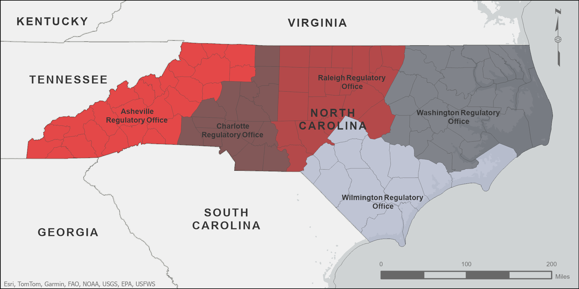
Contact The Wilmington District regulatory program is comprised of five field offices serving the major regions of the state from the mountains to the sea, and a division office located at the main District office in Wilmington, NC.
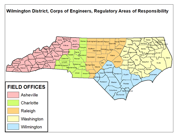
Staff are generally assigned to manage activity within a designated geographic area, usually based on the county. There are also staff who specialize in transportation (NC DOT) projects, coordination with NC Division of Coastal Management (DCM) for coastal (CAMA) activities, and staff that assist with major projects.
Our staff is required to be in the field for site assessments. As such, please be aware that this requirement may result in a delay in obtaining an immediate response.
Questions Regarding Regulatory Permitting
For general questions about the Corps’ Regulatory Program and permitting requirements subject to Section 404 of the Clean Water Act and/or Section 10 of the Rivers and Harbors Act, please send an e-mail to NCPermit-Wetlands@usace.army.mil. Please include a description of your request or issue as well as the address and county where the property is located. Upon receipt, your inquiry will be assigned to a Regulatory Project Manager who will contact you.
You may also contact our staff by clicking on the following link which provides a list of e-mails and telephone numbers of Project Managers by county: staff emails and phone numbers (link to current staff contact information).
Every request is important to us. Due to the volume of calls and messages received, please anticipate 3 business days for a response.
Reporting Suspected Violations
Upon receipt of a report of a suspected violation, we will review the information provided to determine if the matter falls within the jurisdictional authority of our office and whether or not an investigation is warranted. Corps enforcement actions generally fall into two categories:
- A failure of a permittee to comply with the terms or conditions of a Department of the Army Permit issued pursuant to Section 404 of the Clean Water Act (CWA) or Section 10 of the Rivers and Harbors Act (RHA).
- A discharge of dredged or fill material into waters of the United States without a Department of the Army Permit issued pursuant to CWA Section 404 and/or RHA Section 10.
Please note that the Wilmington District does not provide updates or responses to reporting parties during ongoing investigations into potential violations of federal law.
Wilmington District Field Offices
General Contact Telephone Number for all Wilmington District offices: (704) 510-1441
See the staff emails and phone numbers for specific Project Managers contact information
ASHEVILLE REGULATORY FIELD OFFICE
US Army Corps of Engineers
151 Patton Avenue, Room 208
Asheville, North Carolina 28801-5006
CHARLOTTE REGULATORY FIELD OFFICE
US Army Corps of Engineers
8430 University Executive Park Drive, Suite 615
Charlotte, North Carolina 28262
RALEIGH REGULATORY FIELD OFFICE
US Army Corps of Engineers
3331 Heritage Trade Drive, Suite 105
Wake Forest, North Carolina 27587
WASHINGTON REGULATORY FIELD OFFICE
US Army Corps of Engineers
2407 West Fifth Street Washington, NC 27889
WILMINGTON REGULATORY FIELD OFFICE
US Army Corps of Engineers
69 Darlington Avenue
Wilmington, NC 28403